


La Rheorthe

reva17
User

Length
8.1 km

Max alt
103 m

Uphill gradient
147 m
Km-Effort
10.1 km

Min alt
31 m

Downhill gradient
147 m
Boucle
Yes
Creation date :
2014-12-10 00:00:00.0
Updated on :
2014-12-10 00:00:00.0
2h11
Difficulty : Medium

FREE GPS app for hiking
 SityTrail
IGN / Geographical institutes
SityTrail Plus
The world is yours!
About
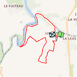
Trail Walking of 8.1 km to be discovered at Pays de la Loire, Vendée, La Réorthe. This trail is proposed by reva17.
Description
Retenue de l'Angle Guignard Coteaux et vallons -Quelques passages difficiles
Positioning
Country:
France
Region :
Pays de la Loire
Department/Province :
Vendée
Municipality :
La Réorthe
Location:
Unknown
Start:(Dec)
Start:(UTM)
649418 ; 5166250 (30T) N.
Comments